Cauca, Cauca, Colombia
Suggest Place to Visit
1024
Track to location with GPS |
 |
Founded date: September 17, 1897
Name of the founder (s): The founder of the Municipality of Puerto Tejada was General Manuel Tejada Sánchez and is named after him.
Historical review:
“… Absenteeism characterizes the administration of large property. In the past, landowners resided in Popayán, and currently in Cali, or in other smaller cities, delegating land administration to mayordomos, while they dedicate their time to political and social activities… ”Virginia Gutiérrez de Pineda, Family and Culture in Colombia, Tercer Mundo-Universidad Nacional, Bogotá, 1968 Puerto Tejada was not founded as the cities that appeared in the normal process of the Spanish Conquest guided by the urban planning guidelines of Carlos V and Felipe II, nor as those that, following republican legal processes In the coffee colonization of the Central Cordillera, at the end of the 19th century and the beginning of the 20th, they were founded during the so-called Antioqueña Colonization of the Quindío mountain range ... Puerto Tejada was founded to “put in order” the blacks of the Palo rivers, Paila and Guengüe. It was in this process of resistance that, during the 18th and 19th centuries, slave and free blacks became impossible for the landowners to control; but with greater force since the enactment of the law to abolish slavery in 1851. Since then, this recently liberated population settled on the haciendas through various forms of colonization to take advantage of the fertility of the lands where they built family farms dedicated to the production of cocoa, tobacco, coffee, cassava, corn and bananas, giving rise to a thriving agricultural economy of settlers and landowners in the late 19th and early 20th centuries; others settled in the forests, such as Monte Oscuro, and began to exploit them agriculturally; To this was added the intervention of Cali and foreign merchants, between both forces they put an end to the slave domination directed at a distance from Popayán. Its foundation takes place in a national context plagued by wars; The Federalist Republic has fallen from the hands of the so-called Regeneration of Núñez y Caro, of a centralist and unitary court, the Catholic Church has been recast as the highest and only educational and religious authority with the Constitution of 1886, the revenge of Bogota has begun to forge against the hegemony of Popayanejos Presidents which will take shape in the five-year period of Rafael Reyes, who dismembered Gran Cauca in 1910; it has passed from the 19th to the 20th century with the Thousand Day War. It is known that the founding of Puerto Tejada began by the inhabitants of the banks of the Palo River who chose the confluence of this and the Paila River as a market and exchange site before the astonished gaze of the landowners of the time such as the descendants of Don Julio Arboleda owners of the large neighboring farms. The site of Monte Oscuro is thus forming a relative but important weekly market of Cacao, Plátano and Guadua around 1890; These blacks and mestizos are the grandchildren or children of maroons and palanqueros, but they themselves are now peasants and settlers, cultivators of farms with a regular market and who lived a relative agricultural prosperity. The first settlers according to reports of Mr. Sabas Casarán from the time of its foundation in 1891, were Don Buenaventura Hernández of Antioqueño origin, his sister Catalina Hernández de Casarán who was married to Isidro Casarán, a native of the Municipality of Buenos Aires, grandfather of Don Sabas Casarán , Don Justiniano Hernández, the mother of Justiniano who was the old patron, Don Juan Prudencio Mancilla who was married to Doña Mónica Hernández, Don Juan Prudencio Cambindo, Rodolfo Lince, Don Vicente Llanos de Cali, and a citizen of Italian origin Juan Campelo. General José Antonio Pinto as Governor of Cauca indicates the date of July 14, 1897 as the day of the founding of Puerto Tejada as a Caloto district, according to decree 299. According to the historian Mariano Sendoya, there were farms and houses in the place since 1871 and the village began to be founded in 1891. It was segregated from Caloto and built into a municipality in 1912. Puerto Tejada is the result of the colonization of flat and low lands that are very different from that of slopes because it is not done with immigrants but by expansion of the population itself on private latifundia and not on vacant land of the nation, of the resistance to the archaic, static and fossilized slave system managed from Popayán, and of the fight for the freedom of the men of African descent that, since the century In the 18th century, they served as the wealth-producing force of Caloto, mainly in the mines and in the latifundista slave farms that now correspond to the north of the current Department or from Cauca: Japio, La Bolsa, Quintero, Pílamo, Guayabital, Güengüe, San Fernando, La Ciénaga, El Ortigal. With Puerto Tejada, 10 more towns arise which accelerate the final decomposition of the colonial and slave regime that survived at the end of the XIX century, and creates the conditions for the entry of commercial capital from Cali and foreigners oriented towards the export of cocoa, tobacco and coffee. and at the beginning of the sugarcane plantation in 1940 and its paroxysmal expansion in 1960-70. According to Jacques Aprile, and taking into account the difficulties of the precise boundaries at that time, both due to the scarce development of surveying or topography as well as the periodic change of course of the water currents, usually adopted as boundaries of the estates. , the most plausible thing is that the current territory of Puerto Tejada has corresponded to Hacienda Guayabital, of which 200 Hás were bought by the Government of Cauca in 1897, from Mr. Manuel José Cobo and hires the surveyor Paz Vargas to make the layout of the population, “17 blocks and 11 fractions of demarcated blocks”, to serve as a settlement first for the hamlet and then for the municipal urban area. As Aprile says, "a people of blacks in the tradition of the seventeenth century Indian reductions." But the need to recover the land and the control of the workforce by the landowners, generated processes of eviction and dispossession of the farmers of northern Cauca, -perhaps one of the first population displacements in the history of Colombia. -, to give rise to a new economy of capitalist order; It is under these circumstances that the town of Puerto Tejada, later converted into a Municipality (1912), was initially created and arose as a result of the struggles waged by blacks to obtain the formal freedom that had been granted to them since 1851.
Physical description:
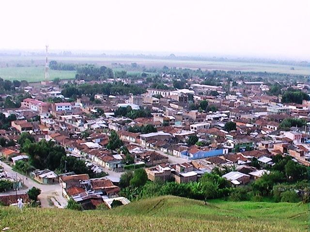
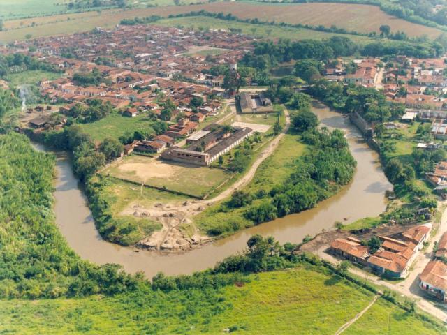
The Buenos Aires territory is located in the northeast part of the Cauca department, it is the gateway from north to south. It has a flat topography, with slopes between 0 and 3%.
Limits of the municipality:
The Municipality of Puerto Tejada has a privileged location: to the North it borders with the Municipalities of Santiago de Cali and Candelaria, to the South with the Municipality of Caloto and Villarrica, to the West with Villarrica and Jamundí, to the East with Miranda and Padilla.
Total extension: The total area of the municipality is 102 square kilometers (11,169.07 hectares). Km2
Urban area extension: 368.1 Km2
Rural area extension: 10,800.97 Km2
Altitude of the municipal seat (meters above sea level): 968 m.s.n.m
Average temperature: 24 º C
Reference distance: Puerto Tejada is located 17 km from the city of Cali and 108 km from Popayán
Agricultural production based on fique, sugar cane, panela cane and coffee. There are minor crops of potatoes, corn, cassava, beans, and tomatoes. Another important line is livestock, highly technical. The Pacific Coast constitutes the largest forest reserve with timber stocks that reach a commercial volume of 4.5 million C3. The main industries are food, beverages, textiles. Fish farming has had a great development in recent times with shrimp farming. On the banks of the Naya River there are large reserves of gold.
Tourist sites
The Bethlehem Chapel, The Humilladero Bridge, The Museum of Religious Art, Casa Caldas, Casa Valencia, Puracé National Park, Tierradentro, The Clock Tower, El Morro del Tulcán, The Monastery Hotel.
Comments
We don´t have yet any comments about:
Puerto Tejada
Puerto Tejada
Be the first to leave a comment as it is very important to inform other people
Outros locais a visitar
Within a radius of 20 km from:Puerto Tejada
Jamundí |
| 14,6 Km |
 |
Ciudad Corinto |
| 18,4 Km |
 |
Hotel reservation near Puerto Tejada within a radius of 20 km
No results
Why to book with RUTAS TURISTICAS
The best prices
Our partnerships with the world´s largest operators offer research on the best market prices.
More options
At Rotas Turisticos you can book the hotel, buy the air ticket, book the transfer from the airport to the hotel and vice versa, book the local excursions, rent the car, take travel insurance and consult the places to visit and where to go.
Holiday Tips & Destinations
Hundreds of holiday destinations with all the options that allow you to easily choose the destination that best suits your dream vacation.
RUTAS TURISTICAS
Links


